July 27, 2005
GeoTagging Flickr via Google Earth - New GreaseMonkey Script
I've written some code that lets you GeoTag your Flickr images via Google Earth, heres the instructions on how to do it.
Requirements:
* Google Earth (An amazingly cool free program that displays the whole world via satellite imagery and lets you zoom right in and fly all round the world, seeing some wonderful sights)
* Firefox Web Browser (you need to enable cookies and you also need to set Firefox as the default web browser in Firefox Tools/options/general menu)
* GreaseMonkey Firefox Extension
* You also need an account on Flickr.com with some uploaded photos in it (the photos need to be publically viewable, the process wont work with photos marked as Private.)
* You also need the following script: GeoTagging Flickr via Google Earth GreaseMonkey Script
Setup Instructions:
1) In order for this script to work properly, you first need to install Google Earth. Once installed you need to go into the Tools/Options/Preferences menu and make sure the box that says "Show web results in external browser" is ticked.
2) If you are running any of my other GeoTagging GM scripts ( i.e "geotag.flickr", "geotag.flickr.streetmapuk", "geotag.flickr.multimap" ) and wish to try this script out, you should disable them in the Tools/Manage User Scripts window. If you wish to go back to using one of the other GM scripts at some point, you need to disable this one, then re-enable the previously disabled script.
3) Open Google Earth, then goto the Places window on the left, right click "My Places" and then select "New Network Link" For the name enter "Flick'rin GeoTagger" and For the location enter the following URL:
http://steeev.freehostia.com/flickr/gearth.php?user=[Put Your Flickr Username Here]
eg if you were me you would use the following URL: http://steeev.freehostia.com/flickr/gearth.php?user=steeev
4) Set "View Based Refresh" to "On Request" and leave all the other options in their default settings then click OK.
5) Now Install this GreaseMonkey script ( Either "Right Click" on the link and select "Install User Script" or click the link and then goto the firefox menu "Tools/Install User Script" ) and you will now have a new link on your Flickr photo pages and batch edit pages called "Add GeoTags"
Usage Instructions
1) Click the "Add GeoTags" link and an input box will be displayed. Enter the address of where the photo/s were taken, then click submit.
2) You will then be sent a KML file (KML=Google Earth XML file format) to your browser.
3) You need to open the KML file with Google Earth, FireFox should automatically popup a window asking what to do with the KML file, and the default option will be to open it in Google Earth. (Tip: If you click the checkbox to always open KML files with Google Earth, you wont need to worry about this step again)
4) Once you have opened the KML file, if Google Earth has found the address you entered, it will display a marker showing the approximate location of the area you wish to GeoTag. If Google Earth did not find the address you entered, you can try a new address search using Google Earth's search search box, until you find the place, or alternatively you can just find the location by rotating and zooming the globe.
5) You now need to move to the exact spot you wish to GeoTag, once you have identified the right location, you should zoom right in on it, so its right at the center of the screeen. You should also ensure that your view point is not tilted, you can do this by clicking the "reset tilt" button.
6) Now right click on the "Flick'rin GeoTagger" network link in the Places window and select "Refresh". A new placemarker will now be displayed at the point you just specified, click the placemarkers icon, and it will pop up a HTML window, now simply click the "Add GeoTags" link in that window and the geotags will be added to your image/s.
7) You then need to either add the "GeoTagged" link to the description or if its not your image, to the comments. So just click the appropriate button. You can also add a link to "Fly to that location in Google Earth" See RobRoyAus's post on the subject for more info.
Adding The GeoTagged link is useful for 2 reasons; Clicking it the first time adds your images location to the geobloggers.com database, and subsequent clicks on it will display the location of the image overlaid on a map. Once its in the geobloggers database, you will be able to view it in Google Earth and other people will be able to find it by searching by location etc on the geobloggers site.
While it might seem like a lot of steps, you should only need to do the steps in the Setup section the first time you use the script, after that you would just use the steps listed under the "Usage Instructions" heading :)
If you have any ideas or suggestions on how to improve the process, please let me know.
Cheers,
steeev
Tags: GoogleEarth | Google | geolocation | geocoder | geocoding | geotagging | flickr | greasemonkey | photos | photography | StreetMap
July 22, 2005
BrainStorming:- GeoTagging Images via Google Earth?
Ive been toying with the idea of creating some kind of geotagging interface that utilises Google Earth, anyone got any ideas or suggestions as to how it could be done.
heres a few ideas ive had so far
1) use the network link, once you have found the spot you want to geotag, zoom right in then refresh the network link which sends the current bounding box (BBOX) value to a server. From the BBox data, it should be possible to work out the central coordinate and then store/use it for geotagging. i guess the server would need to cross reference the users ipaddress, with the ip address that sent the BBOX data.
BTW does anyone have an algorithm for finding the central coordinate given the BBOX data?
2) use the email placemarker function, to email the location to a script that continually checks a pop mail box, in the email you could include a title and description, or comments
the script will store the location and or add it to a list of that users locations, which when they login to the server, then can use the emailed in locations like bookmarks similar to the way CK's script works at present for geotagging images
3) save the positions as placemark kml files, then once youve finished saving locations. upload the kml files to a server, which will process them and store the locations similar to the previous idea
4) this might be a bit drastic, but my other idea is to somehow add a geotagging function directly into the google earth executable file, by way of a patch of some sort, not sure how feasible this is though.
anyone else got any ideas on how this could be done?
UPDATE I finally got round to coding this, you can read about it here
Technorati Tags: geolocation | geocoder | geocoding | geotagging | flickr | greasemonkey | photos | photography | StreetMap
July 20, 2005
Over 30,000 Flickr Images have now been GeoTagged!
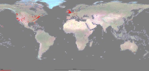
This map displays the locations of 20,992 GeoTagged Flickr Images (Snapshot taken on 08-Jul-05)

This map displays the locations of 30,222 GeoTagged Flickr Images (Snapshot taken on 11-Jul-05)
Each dot on the maps represent one or more GeoTagged Flickr images.
I downloaded the coordinate data from www.geobloggers.com as a CSV file then plotted it on the world map using the very cool www.gpsvisualizer.com service.
Since GoogleMaps have increased their satellite imagery coverage of the world, it seems to have coincided with more and more images being geotagged worldwide, outside of the USA/Canada + UK/Ireland where the first 10,000 or so were mainly clustered around.
Contrast the above maps, with this one  which is a world population density map, the darker red areas are the most heavily populated.
Technorati Tags: googlemaps | google | geolocation | geotagging | flickr | greasemonkey | photos | photography | maps