July 20, 2005
Over 30,000 Flickr Images have now been GeoTagged!
This map displays the locations of 20,992 GeoTagged Flickr Images (Snapshot taken on 08-Jul-05)

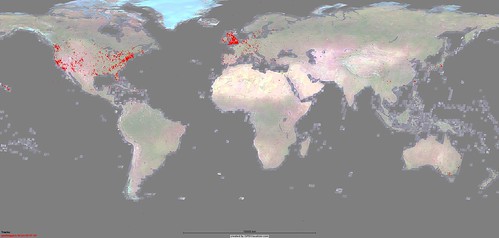
This map displays the locations of 30,222 GeoTagged Flickr Images (Snapshot taken on 11-Jul-05)
Each dot on the maps represent one or more GeoTagged Flickr images.
I downloaded the coordinate data from www.geobloggers.com as a CSV file then plotted it on the world map using the very cool www.gpsvisualizer.com service.
Since GoogleMaps have increased their satellite imagery coverage of the world, it seems to have coincided with more and more images being geotagged worldwide, outside of the USA/Canada + UK/Ireland where the first 10,000 or so were mainly clustered around.
Contrast the above maps, with this one  which is a world population density map, the darker red areas are the most heavily populated.
Technorati Tags: googlemaps | google | geolocation | geotagging | flickr | greasemonkey | photos | photography | maps
Posted by steeev to Firefox | Flickr | GeoLocation | GeoLocation | Google Maps Hacking at July 20, 2005 04:49 AM